Western Alaska has been experiencing wind chill readings down into the 30s, 40s, and even 50s below zero for the past several days. One climatologist says that trend of cold temperatures is likely to last the rest of the week, but the region still won’t be as cold as he remembers.
“We’ve got quite a cold air mass across all of mainland Alaska at this point, including Western Alaska …”
– Rick Thoman
Rick Thoman is a climate specialist with the Alaska Center for Climate Assessment and Policy (ACCAP). But before that he was employed with the National Weather Service. Thoman recalls an earlier point in his climate career, 31 years ago, when he saw record cold temperatures at his office in Nome.
“January 27th, 1989. I was on a stretch of evening shifts at the weather service at the Nome airport. I was a young intern, I had been in Nome about a year-and-a-half at that point. It did get into the 50s below that evening, it got down to -54 ° below zero before I got off work at midnight. When the jet left in the early evening, it created ice fog.”
Thoman says he remembers getting a few phone calls that night asking what the temperature was, as that information was not available on the internet during that time. Modern internet did not exist in 1989.
According to NWS records, and Thoman’s notes from 1989, some of the coldest temps on record were set in late January of 1989. Besides Nome’s -54°, other Western Alaska communities saw -55°, -61°, and even -72° in St. Michael, Koyuk, and Aniak respectively.
Although the Bering Strait region is not feeling temperatures quite that cold today, Thoman says a cold high pressure in the area has brought consistent sub-zero degree days with it.
“We do, at this point, see something of a change on the horizon, especially for Western Alaska, with the coldest air retreating a bit to the east and allowing at least somewhat milder air in, perhaps a weather front, to work into the region; perhaps in a week from now. But certainly we don’t see any kind of turn towards persistently stormy weather like we had last year at this time.”
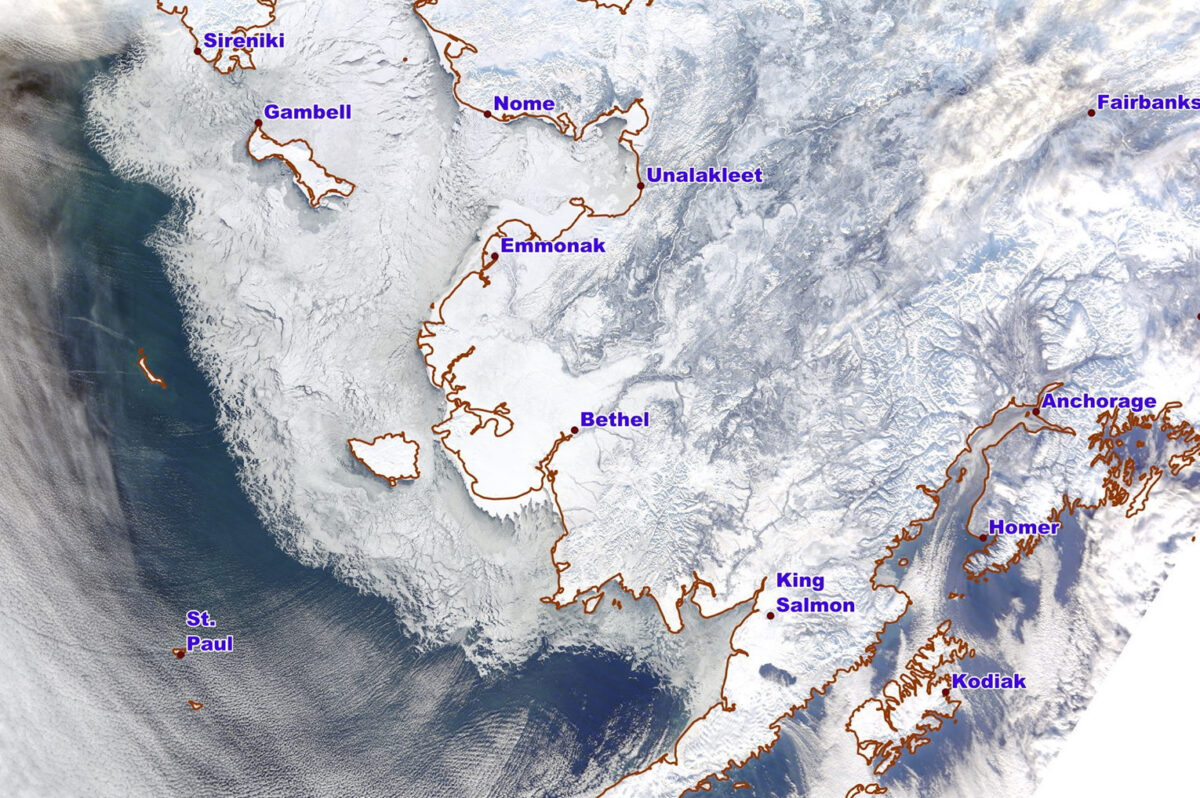
Though not very beneficial for Western Alaskans spending long periods of time outside, this cold-stretch has been good for sea ice growth. Thoman says before the cold temperatures break away, sea ice is likely to reach St. Matthew Island in the central Bering Sea.
“After that though, that little bit of a weather pattern change is likely to bring a halt to the movement of the ice. While it doesn’t look like that change is going to be enough to cause any great sea ice retreat, it’s probably going to bring an end to the recent growth.”
Thoman points out that although the sea ice has grown significantly in late January, it’s still below the normal extent for this time of year.
Wind chill advisories issued by the National Weather Service, for several regions in Western Alaska, warn residents of the risks for frost bite or hypothermia if their skin is exposed for ten minutes or more during these frigid conditions.
Image at top: Sea ice extent in the Bering Sea as of January 25th, 2020. Photo courtesy of Rick Thoman with UAF’s ACCAP, used with permission.


